


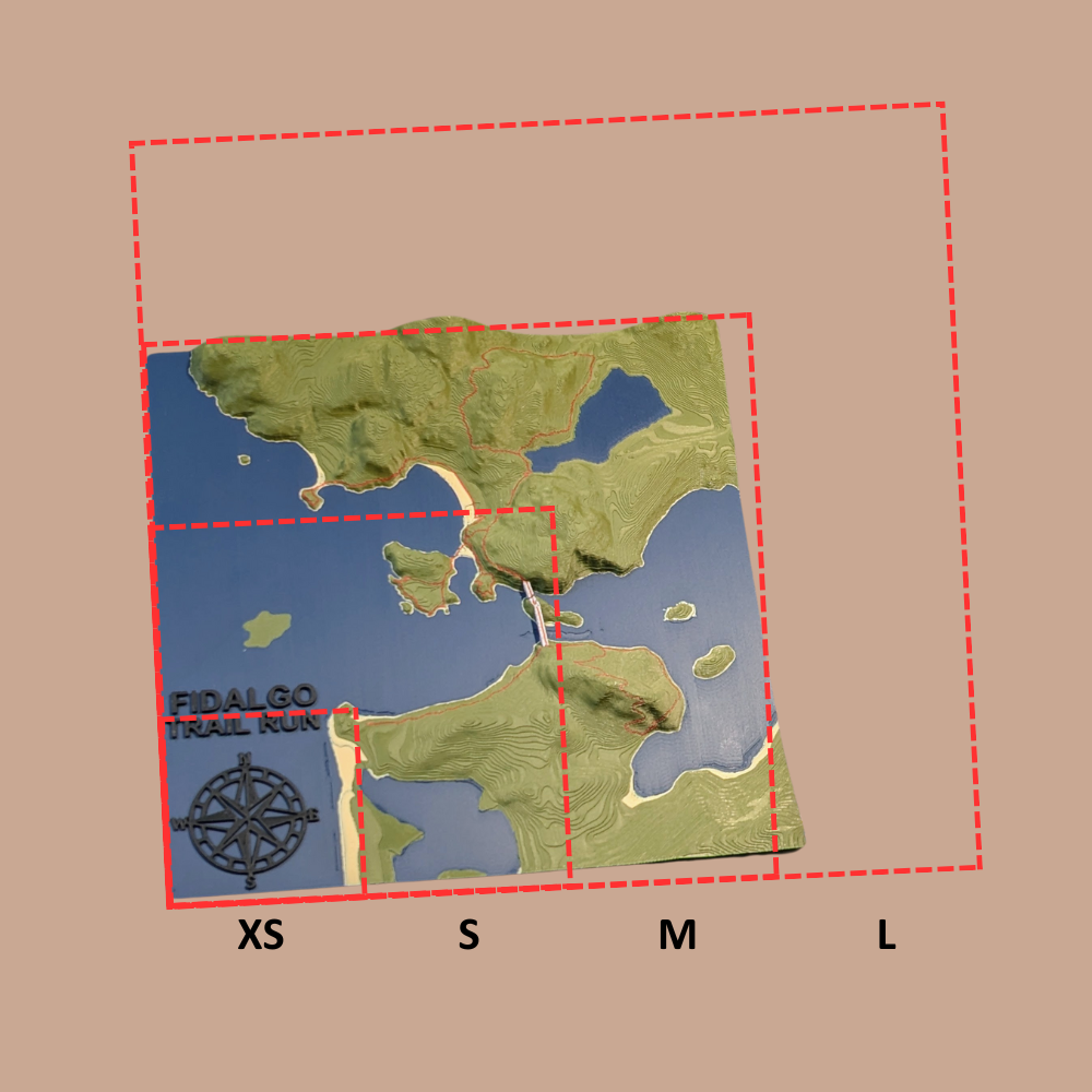
Size Guide

INSTRUCCIONES DEL MAPA / AYUDA
- Desplácese o acerque la ubicación de su foto.
- Haz clic en el mapa. Aparecerá un recuadro rojo. El centro se fijará en el punto donde hiciste clic.
- Ajusta el tamaño del cuadro rojo como desees (este será el límite del mapa). La forma se forzará a ser cuadrada.
- Desplácese hacia arriba hasta Selección de mapa y marque la casilla de verificación.
✳️ Todos los datos de coordenadas pasarán junto con tu pedido cuando hagas clic en Agregar al carrito .
✳️ La dirección Z del mapa (elevación) probablemente se exagerará 1,5X para obtener mejores resultados.
How it's crafted
-

Material
Polylactic Acid (PLA) plastic is considered an eco-friendly material because it's a biodegradable polymer derived from renewable resources like corn starch or sugarcane. This contrasts with traditional plastics, which are made from non-renewable petroleum. PLA's environmental benefits are primarily due to its sustainable origin and its ability to decompose under specific conditions.
Using PLA means that your product, should it be disposed of correctly, will have a much smaller environmental footprint compared to maps made from traditional plastics like ABS or PET. -

3D Printing Process
1. Digital Preparation
We start by converting high-resolution public topographic data into a 3D printable file. Using slicing software, chop up the model with:
- layer heights down to 0.10mm
- layer widths down to 0.20mm using the smallest available nozzles to capture the finest details of the terrain
2. Printing and Monitoring
We use Bambu Lab 3D printers known for their speed and precision. Each printer has:
- HD camera for 100% video monitoring
- integrated AI system that automatically screens for defects in real-time
- Print bed up to 250x250mm
-

Quality
After printing, every map undergoes a final manual inspection. We check for dimensional accuracy, surface finish, and structural integrity before moving forward. This meticulous process ensures every map we create is a durable, highly-detailed, and accurate representation of the terrain.
Favoritos
-

1) TopoPhoto - Personalizado
Captura recuerdos inolvidables con Topophoto, un marco personalizado que fusiona tus fotos...
-

2) TopoMap - Personalizado
Mapas topográficos 3D personalizados
-

National Park Maps
A collection of scenic National Parks in both TopoMaps and TopoPhotos!


