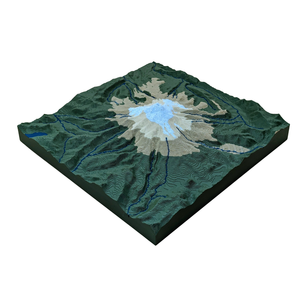
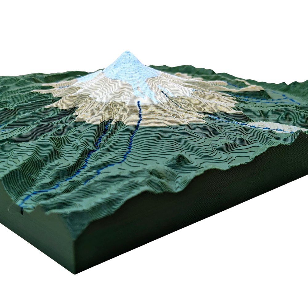
¡Embárcate en una pequeña excursión al Monte Hood! Este mapa a escala 1:1 incluye los mejores senderos, miradores y ríos en un tamaño compacto. ¡Explora la belleza y la aventura con este mapa topográfico!
Polylactic Acid (PLA) plastic is considered an eco-friendly material because it's a biodegradable polymer derived from renewable resources like corn starch or sugarcane. This contrasts with traditional plastics, which are made from non-renewable petroleum. PLA's environmental benefits are primarily due to its sustainable origin and its ability to decompose under specific conditions.
Using PLA means that your product, should it be disposed of correctly, will have a much smaller environmental footprint compared to maps made from traditional plastics like ABS or PET.
3D Printing Process
1. Digital Preparation
We start by converting high-resolution public topographic data into a 3D printable file. Using slicing software, chop up the model with:
layer heights down to 0.10mm
layer widths down to 0.20mm using the smallest available nozzles to capture the finest details of the terrain
2. Printing and Monitoring
We use Bambu Lab 3D printers known for their speed and precision. Each printer has:
HD camera for 100% video monitoring
integrated AI system that automatically screens for defects in real-time
Print bed up to 250x250mm
Quality
After printing, every map undergoes a final manual inspection. We check for dimensional accuracy, surface finish, and structural integrity before moving forward. This meticulous process ensures every map we create is a durable, highly-detailed, and accurate representation of the terrain.
<div class="dynamic-checkout__content" id="dynamic-checkout-cart" data-shopify="dynamic-checkout-cart"> <shopify-accelerated-checkout-cart wallet-configs="[{"name":"shop_pay","wallet_params":{"shopId":68141777095,"merchantName":"MAOS Maps","personalized":true}},{"name":"paypal","wallet_params":{"shopId":68141777095,"countryCode":"US","merchantName":"MAOS Maps","phoneRequired":true,"companyRequired":false,"shippingType":"shipping","shopifyPaymentsEnabled":true,"hasManagedSellingPlanState":false,"requiresBillingAgreement":false,"merchantId":"UGCHWB7Z76L56","sdkUrl":"https://www.paypal.com/sdk/js?components=buttons\u0026commit=false\u0026currency=USD\u0026locale=es_ES\u0026client-id=AbasDhzlU0HbpiStJiN1KRJ_cNJJ7xYBip7JJoMO0GQpLi8ePNgdbLXkC7_KMeyTg8tnAKW4WKrh9qmf\u0026merchant-id=UGCHWB7Z76L56\u0026intent=authorize"}}]" access-token="dc93679f2c6e9358f5bf9f161bbe1de6" buyer-country="US" buyer-locale="es" buyer-currency="USD" shop-id="68141777095" cart-id="2f9b4590bc7635ccb15096f426e56fcb" enabled-flags="["ae0f5bf6"]" > <div class="wallet-button-wrapper"> <ul class='wallet-cart-grid wallet-cart-grid--skeleton' role="list" data-shopify-buttoncontainer="true"> <li data-testid='grid-cell' class='wallet-cart-button-container'><div class='wallet-cart-button wallet-cart-button__skeleton' role='button' disabled aria-hidden='true'> </div></li><li data-testid='grid-cell' class='wallet-cart-button-container'><div class='wallet-cart-button wallet-cart-button__skeleton' role='button' disabled aria-hidden='true'> </div></li> </ul> </div> </shopify-accelerated-checkout-cart> <small id="shopify-buyer-consent" class="hidden" aria-hidden="true" data-consent-type="subscription"> Uno o más de los artículos que hay en tu carrito forman parte de una compra recurrente o diferida. Al continuar, acepto la <span id="shopify-subscription-policy-button">política de cancelación</span> y autorizo a realizar cargos en mi forma de pago según los precios, la frecuencia y las fechas indicadas en esta página hasta que se prepare mi pedido o yo lo cancele, si está permitido. </small> </div>
Al seleccionar una opción, se actualiza toda la página.