


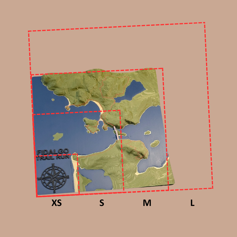
Size Guide

Instructions / Help
- Pan / zoom to your photo location.
- Click on the map. A red box will appear. The center will be locked on where you clicked.
- Resize the red box as desired (this will be the map boundary). The shape is forced to be square.
- Scroll up to Map Selection and check the verification box.
✳️All coordinate data will pass through with your order when you click Add to Cart.
✳️The map Z direction (elevation) will likely be exaggerated 1.5X for best results.
How it's crafted
-

Material
Polylactic Acid (PLA) plastic is considered an eco-friendly material because it's a biodegradable polymer derived from renewable resources like corn starch or sugarcane. This contrasts with traditional plastics, which are made from non-renewable petroleum. PLA's environmental benefits are primarily due to its sustainable origin and its ability to decompose under specific conditions.
Using PLA means that your product, should it be disposed of correctly, will have a much smaller environmental footprint compared to maps made from traditional plastics like ABS or PET. -

3D Printing Process
1. Digital Preparation
We start by converting high-resolution public topographic data into a 3D printable file. Using slicing software, chop up the model with:
- layer heights down to 0.10mm
- layer widths down to 0.20mm using the smallest available nozzles to capture the finest details of the terrain
2. Printing and Monitoring
We use Bambu Lab 3D printers known for their speed and precision. Each printer has:
- HD camera for 100% video monitoring
- integrated AI system that automatically screens for defects in real-time
- Print bed up to 250x250mm
-

Quality
After printing, every map undergoes a final manual inspection. We check for dimensional accuracy, surface finish, and structural integrity before moving forward. This meticulous process ensures every map we create is a durable, highly-detailed, and accurate representation of the terrain.
All Collections
-

TopoPhoto - Custom
Your favorite picture and its location brought back to life - all...
-

TopoMap - Custom
Standalone custom 3D topographical maps Custom | Single Tile | 100-200mm [4-8"]...
-

National Park Maps
A collection of scenic National Parks in both TopoMaps and TopoPhotos!


