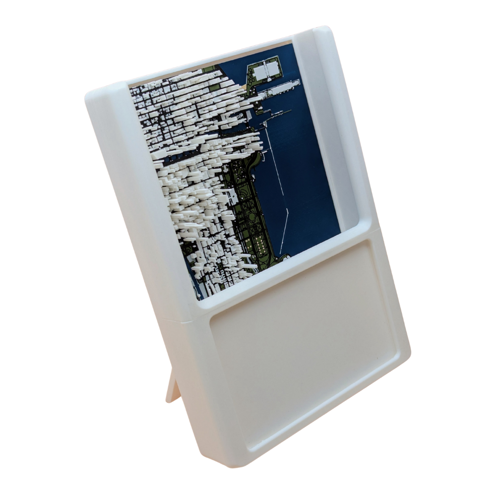
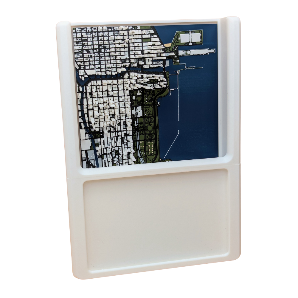
Experience your favorite memories like never before with TopoPhoto Frame LED City. This ready-to-ship photo frame features a stunning illuminated 3D topographical map of city of Chicago. Immerse yourself in the moment with a unique, geographic perspective that will give your memories dimension! Just slip your own 4x6 photo in the frame to make it yours!
Product Details
🗺️💖 4x6 photo frame and 3D topographical map for your special memory
🖼️ Pop-out stand & wall mount
💡 Illuminated map with integrated battery pack lasts 72 continuous hours using 3x AA batteries (not included)
Specifications
📏 Overall Size: 10" x 7" x 1.5"
⚖️ Weight: 1.75 lbs
Polylactic Acid (PLA) plastic is considered an eco-friendly material because it's a biodegradable polymer derived from renewable resources like corn starch or sugarcane. This contrasts with traditional plastics, which are made from non-renewable petroleum. PLA's environmental benefits are primarily due to its sustainable origin and its ability to decompose under specific conditions.
Using PLA means that your product, should it be disposed of correctly, will have a much smaller environmental footprint compared to maps made from traditional plastics like ABS or PET.
3D Printing Process
1. Digital Preparation
We start by converting high-resolution public topographic data into a 3D printable file. Using slicing software, chop up the model with:
layer heights down to 0.10mm
layer widths down to 0.20mm using the smallest available nozzles to capture the finest details of the terrain
2. Printing and Monitoring
We use Bambu Lab 3D printers known for their speed and precision. Each printer has:
HD camera for 100% video monitoring
integrated AI system that automatically screens for defects in real-time
Print bed up to 250x250mm
Quality
After printing, every map undergoes a final manual inspection. We check for dimensional accuracy, surface finish, and structural integrity before moving forward. This meticulous process ensures every map we create is a durable, highly-detailed, and accurate representation of the terrain.
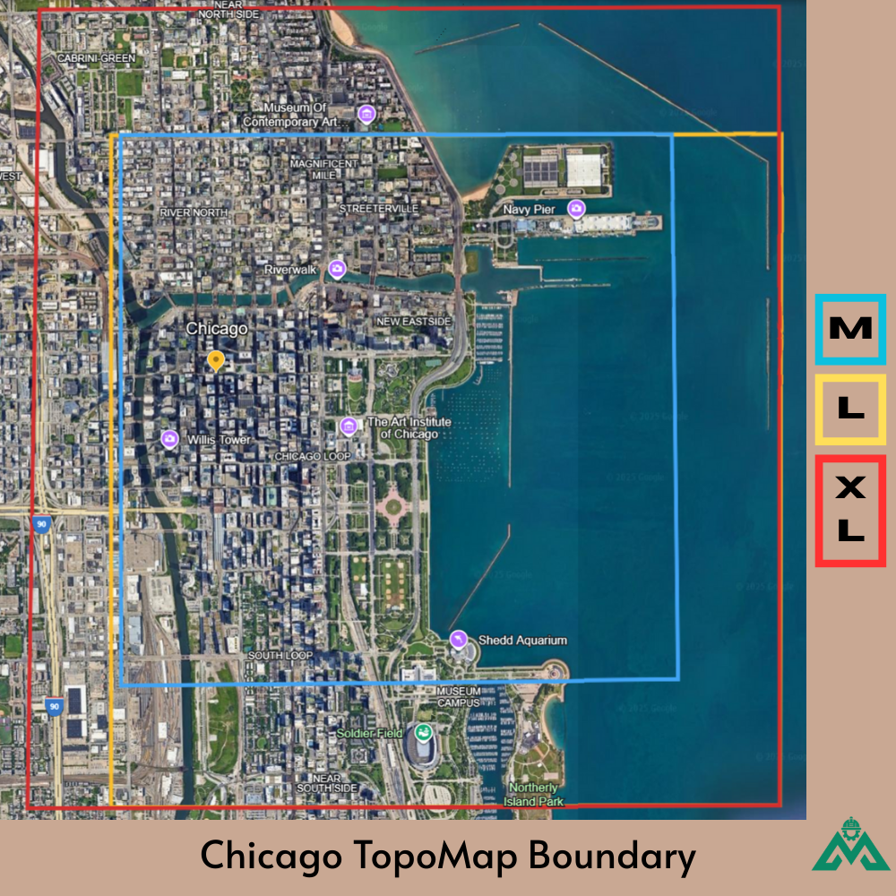
I was searching for a 3D topo map of Chicago that fully included Navy Pier, and this one works. The overall dimensions of the map allow me to see the major features of the city.
Hi there! Thank you for taking the time to leave a review. We are delighted to hear that you are enjoying the 'view' of Chicago! We do apologize for the delay in your order as it did take longer than usual and appreciated your patience and ultimately the positive review!
<div class="dynamic-checkout__content" id="dynamic-checkout-cart" data-shopify="dynamic-checkout-cart"> <shopify-accelerated-checkout-cart wallet-configs="[{"name":"shop_pay","wallet_params":{"shopId":68141777095,"merchantName":"MAOS Maps","personalized":true}},{"name":"amazon_pay","wallet_params":{"checkoutLanguage":"en_US","ledgerCurrency":"USD","placement":"Cart","sandbox":false,"merchantId":"A1KOH71YVCKQC4","productType":"PayAndShip","design":"C0002"}},{"name":"paypal","wallet_params":{"shopId":68141777095,"countryCode":"US","merchantName":"MAOS Maps","phoneRequired":true,"companyRequired":false,"shippingType":"shipping","shopifyPaymentsEnabled":true,"hasManagedSellingPlanState":false,"requiresBillingAgreement":false,"merchantId":"UGCHWB7Z76L56","sdkUrl":"https://www.paypal.com/sdk/js?components=buttons\u0026commit=false\u0026currency=USD\u0026locale=en_US\u0026client-id=AbasDhzlU0HbpiStJiN1KRJ_cNJJ7xYBip7JJoMO0GQpLi8ePNgdbLXkC7_KMeyTg8tnAKW4WKrh9qmf\u0026merchant-id=UGCHWB7Z76L56\u0026intent=authorize"}}]" access-token="dc93679f2c6e9358f5bf9f161bbe1de6" buyer-country="US" buyer-locale="en" buyer-currency="USD" shop-id="68141777095" cart-id="c6941a6d5e15fcf96245a7b6d0f82a9a" > <div class="wallet-button-wrapper"> <ul class='wallet-cart-grid wallet-cart-grid--skeleton' role="list" data-shopify-buttoncontainer="true"> <li data-testid='grid-cell' class='wallet-cart-button-container'><div class='wallet-cart-button wallet-cart-button__skeleton' role='button' disabled aria-hidden='true'> </div></li><li data-testid='grid-cell' class='wallet-cart-button-container'><div class='wallet-cart-button wallet-cart-button__skeleton' role='button' disabled aria-hidden='true'> </div></li><li data-testid='grid-cell' class='wallet-cart-button-container'><div class='wallet-cart-button wallet-cart-button__skeleton' role='button' disabled aria-hidden='true'> </div></li> </ul> </div> </shopify-accelerated-checkout-cart> <small id="shopify-buyer-consent" class="hidden" aria-hidden="true" data-consent-type="subscription"> One or more of the items in your cart is a recurring or deferred purchase. By continuing, I agree to the <span id="shopify-subscription-policy-button">cancellation policy</span> and authorize you to charge my payment method at the prices, frequency and dates listed on this page until my order is fulfilled or I cancel, if permitted. </small> </div>
Choosing a selection results in a full page refresh.