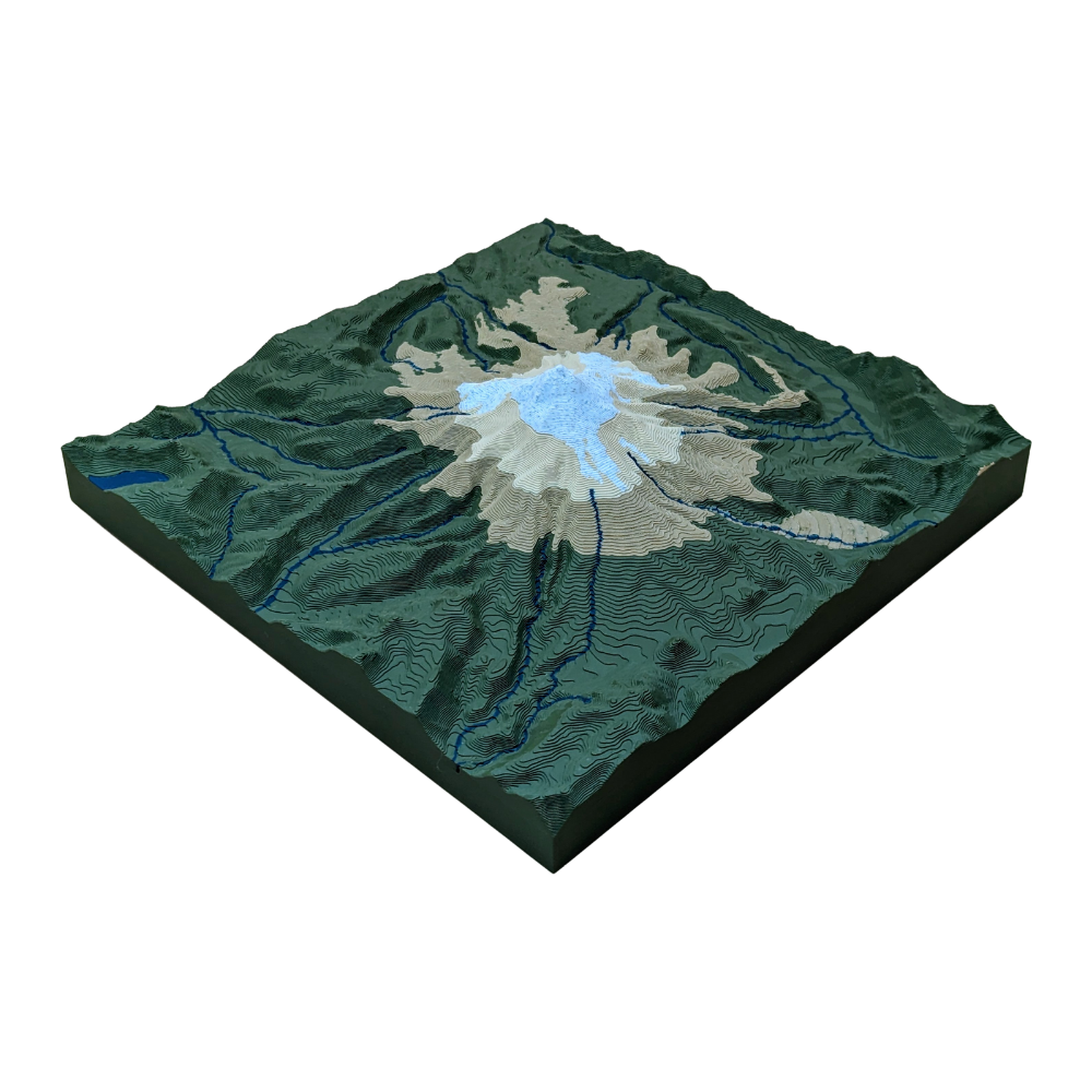
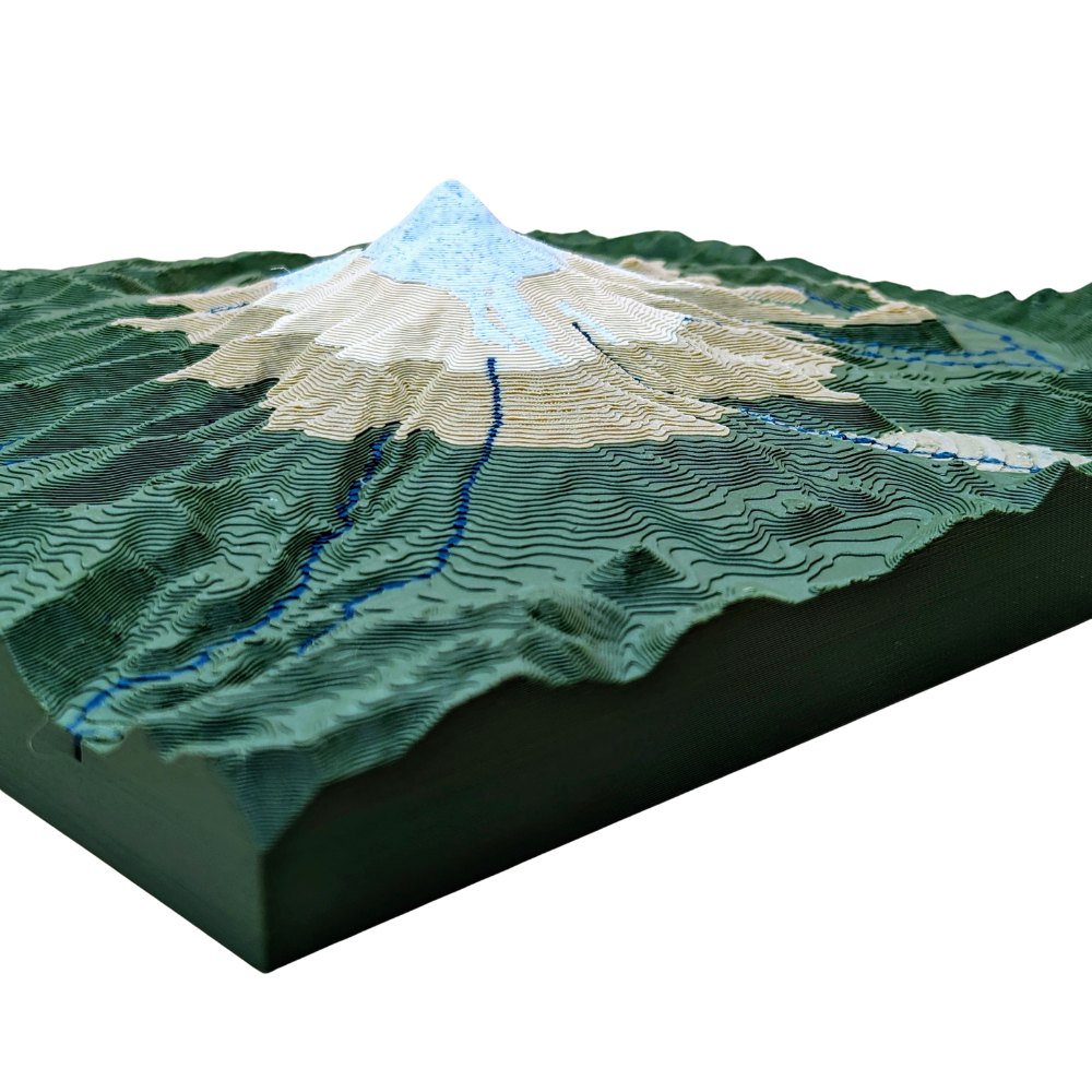
Partez pour une petite randonnée jusqu'au Mont Hood ! Cette carte à l'échelle 1:1 présente les meilleurs sentiers, points de vue et rivières dans un format compact. Explorez la beauté et l'aventure avec cette carte topographique !
Polylactic Acid (PLA) plastic is considered an eco-friendly material because it's a biodegradable polymer derived from renewable resources like corn starch or sugarcane. This contrasts with traditional plastics, which are made from non-renewable petroleum. PLA's environmental benefits are primarily due to its sustainable origin and its ability to decompose under specific conditions.
Using PLA means that your product, should it be disposed of correctly, will have a much smaller environmental footprint compared to maps made from traditional plastics like ABS or PET.
3D Printing Process
1. Digital Preparation
We start by converting high-resolution public topographic data into a 3D printable file. Using slicing software, chop up the model with:
layer heights down to 0.10mm
layer widths down to 0.20mm using the smallest available nozzles to capture the finest details of the terrain
2. Printing and Monitoring
We use Bambu Lab 3D printers known for their speed and precision. Each printer has:
HD camera for 100% video monitoring
integrated AI system that automatically screens for defects in real-time
Print bed up to 250x250mm
Quality
After printing, every map undergoes a final manual inspection. We check for dimensional accuracy, surface finish, and structural integrity before moving forward. This meticulous process ensures every map we create is a durable, highly-detailed, and accurate representation of the terrain.
<div class="dynamic-checkout__content" id="dynamic-checkout-cart" data-shopify="dynamic-checkout-cart"> <shopify-accelerated-checkout-cart wallet-configs="[{"name":"shop_pay","wallet_params":{"shopId":68141777095,"merchantName":"MAOS Maps","personalized":true}},{"name":"paypal","wallet_params":{"shopId":68141777095,"countryCode":"US","merchantName":"MAOS Maps","phoneRequired":true,"companyRequired":false,"shippingType":"shipping","shopifyPaymentsEnabled":true,"hasManagedSellingPlanState":false,"requiresBillingAgreement":false,"merchantId":"UGCHWB7Z76L56","sdkUrl":"https://www.paypal.com/sdk/js?components=buttons\u0026commit=false\u0026currency=USD\u0026locale=fr_FR\u0026client-id=AbasDhzlU0HbpiStJiN1KRJ_cNJJ7xYBip7JJoMO0GQpLi8ePNgdbLXkC7_KMeyTg8tnAKW4WKrh9qmf\u0026merchant-id=UGCHWB7Z76L56\u0026intent=authorize"}}]" access-token="dc93679f2c6e9358f5bf9f161bbe1de6" buyer-country="US" buyer-locale="fr" buyer-currency="USD" shop-id="68141777095" cart-id="ecc15ea875a198795f082f107001c74a" enabled-flags="["ae0f5bf6"]" > <div class="wallet-button-wrapper"> <ul class='wallet-cart-grid wallet-cart-grid--skeleton' role="list" data-shopify-buttoncontainer="true"> <li data-testid='grid-cell' class='wallet-cart-button-container'><div class='wallet-cart-button wallet-cart-button__skeleton' role='button' disabled aria-hidden='true'> </div></li><li data-testid='grid-cell' class='wallet-cart-button-container'><div class='wallet-cart-button wallet-cart-button__skeleton' role='button' disabled aria-hidden='true'> </div></li> </ul> </div> </shopify-accelerated-checkout-cart> <small id="shopify-buyer-consent" class="hidden" aria-hidden="true" data-consent-type="subscription"> Au moins un article de votre panier constitue un achat récurrent ou différé. En continuant, j’accepte la <span id="shopify-subscription-policy-button">politique de résiliation</span> et vous autorise à facturer mon moyen de paiement aux prix, fréquences et dates listées sur cette page jusqu’à ce que ma commande soit traitée ou que je l’annule, si autorisé. </small> </div>
Le choix d'une sélection entraîne l'actualisation de la page entière.